

• Comparison of satellite imagery from 1990 and 2025 reveals rapid urban growth into river’s natural floodplain
• Suparco warns floodwaters more likely to overtop banks, inundate settlements
• Experts stress need for detailed hydrological studies before using floodplain for urban or agri-expansion
• RUDA claims measures in place to protect developed areas in case of future floods
AN ANALYSIS of satellite imagery spanning 35 years has revealed rapid urban expansion into the floodplain of the River Ravi, raising concerns that land that appears dry for much of the year is gradually losing its ability to accommodate floodwaters during extreme monsoon events.
Official imagery, released by the Space and Upper Atmosphere Research Commission (Suparco) on its web portal ‘Space4Climate’, allows for a comparison of Landsat images from 1990 and 2025.
The comparison shows that Lahore has expanded rapidly towards and into the Ravi floodplain over the last three-and-a-half decades.
The issue has another dimension as well, because under the 1960 Indus Waters Treaty, the waters of the Ravi, along with the Sutlej and Beas, have been allocated to India.
As a result, the Ravi downstream of the border generally remains dry for much of the year, except during the monsoon season, or periods of flood releases.
In the past, Pakistan would receive advance flood information and daily gauge and discharge data from India under the treaty’s mechanisms.
However, since 2025, after New Delhi unilaterally held the treaty in abeyance and stopped communicating with Islamabad, advance warning of fluctuations in the river’s flows has been completely absent.
1990-2025 comparison
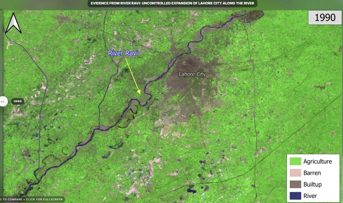
According to an analysis of historical satellite images from 1990, urban settlements remained relatively compact and were largely set back from the river corridor, while agriculture dominated much of the surrounding landscape.
At the time, the river itself maintained a wider and comparatively unconstrained channel.
However, more recent imagery from 2025 reveals extensive urban growth, with settlements and infrastructure spreading aggressively towards the riverbanks and lands that were previously used for farming, or formed part of the natural riverbed.
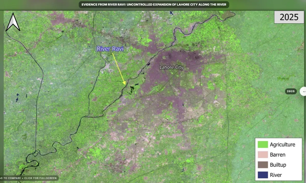
According to Suparco, unplanned development had substantially narrowed the floodplain, limiting its ability to absorb and convey excess water during extreme weather events.
“As a result, floodwaters are more likely to overtop banks, inundate settlements and cause severe damage to infrastructure and livelihoods,” it noted.
The agency observed that urban encroachment into the riverbed had heightened Lahore’s exposure to flood risks and underscored the need to incorporate river dynamics into urban planning.
It also recommended strict enforcement of floodplain zoning regulations and protection of the river’s right-of-way to prevent further encroachments and mitigate the impact of future flooding.
The findings come amid increasing concerns over the impact of rapid urbanisation and changing weather patterns on flood risks in Punjab, where experts have repeatedly warned that unchecked development along waterways and natural drainage channels has reduced the resilience of cities to extreme rainfall events.
A Punjab Irrigation Department report on floodplain demarcation from October 2025, seen by Dawn, stated that the officially-notified Ravi floodplain covered approximately 230 sq km in 2016.
A senior Irrigation Department official told Dawn that as the river experienced its highest flood in nearly 33 years, around three square kilometres had effectively been added to the floodplain area in 2025, highlighting the increasing pressure on the river’s natural flood corridor.
Shifting landscape
Prof Dr Noor Muhammad, who heads the Civil Engineering department at the University of Engineering and Technology (UET), Lahore, told Dawn that the floodplain of a river was not static, but changed over time as the river naturally shifted its course.
He said the Ravi was once surrounded by forests before large tracts were converted into agricultural land, while efforts were now under way to channelise parts of the river to facilitate urban development.
He said that many countries had adopted river channelisation techniques to regulate water flow by controlling the river’s slope, removing obstructions and constructing protective embankments or retaining walls.
Such engineering measures, he said, were preceded by detailed hydrological studies and could enable floodplain land to be used for urban development or agriculture while reducing flood risks.
Environmental lawyer and activist Ahmad Rafay Alam referred to examples such as London and Paris, which had also developed around floodplains. However, authorities there had invested in systems and planning frameworks to protect populations from flooding, he said.
In contrast, unchecked urbanisation in Lahore was also affecting the environment, he said, stressing the need for preserving and developing green spaces in the city.
Mr Alam said the Punjab government had enacted legislation for floodplain protection, but the law did not apply to the river corridor and areas falling under the Ravi Urban Development Authority (RUDA).
Protective measures
A spokesperson for RUDA, which currently controls most of the land within what used to be the river’s floodplain, said the authority’s master plan was based on hydrological studies and numerical and physical modelling using several years’ worth of data.
He said RUDA had sought to “permanently address” flood risks by developing a one-kilometre-wide and six-metre-deep river creek, capable of carrying flood flows of up to 600,000 cusecs with a 10pc freeboard through three barrages planned along the 47-kilometre project area.
The spokesperson maintained that no approved housing schemes were located within the floodplain. Of the over 100 housing societies falling within the RUDA area, around 10 had received approvals and about 35 were still under consideration, while the remaining schemes would be required to comply with the authority’s bylaws and safety requirements before being allowed to operate.
He said flood modelling had been carried out before recent monsoon seasons and that the authority’s planning framework incorporated flood, sediment, groundwater and water availability studies.
According to him, the maximum flood recorded in 2025 was around 230,000 cusecs, adding that areas protected by RUDA-built promenades had remained safe from inundation.
The spokesperson attributed flooding witnessed in some localities to non-compliance with RUDA regulations, and said the authority had accelerated work on embankments and other riverfront infrastructure.
He also claimed that 80 homes within a private housing society, which were inundated by last year’s floods, had been demolished as they were located within the floodplain. In addition, six to eight other housing societies that also occupied floodplain areas had been directed to develop embankments.
Published in Dawn, July 4th, 2026

No comments yet. Be the first to comment!
Your trusted source for breaking news, in-depth analysis, and comprehensive coverage of today's most important stories.
Get daily updates on breaking news, exclusive interviews, and special features delivered to your inbox.
Have a news tip or want to get in touch with our editorial team? We're here to help.
Plot C3-C Jaypee Wishtown Sector 129 Noida Uttar Pradesh 201304 India